Bremer Bay Airstrip

Bremer Bay Airstrip
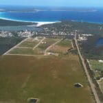
Over the last few years, the Bremer Bay Airport has grown in popularity, especially amongst recreational pilots. It is located just outside of Bremer Bay, approximately. 2.5km to the northwest of the town site (Latitude –34.38056, Longitude 119.33194, Elevation 100ft).
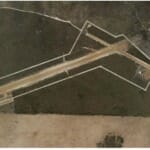
The Bremer Bay Airport is owned and operated by the Shire of Jerramungup, landing permission is currently not required. The existing airstrip consists of a 1200m, 12/30 gravel runway. Additionally there is a 06/24 cross strip of 700m which is generally used for taxiing and has also previously been used as a runway in adverse wind conditions. The windsock is located on the south side of the airfield, at the intersection of the runway and taxiway. Upgrades and development are currently under review by the Shire of Jerramungup.
Aerial attractions include seasonal whale sightings from May to September, the Fitzgerald River National Park, the Bremer Canyon and spectacular landscapes, coastline and islands to fly over. For runway condition reports and operational questions please contact the Shire ranger on 0429 351 022. Local weather conditions can be sourced from the Department of Food and Agriculture’s database (DAFWA App). Most Bremer Bay businesses offer airstrip pick-ups and drop-offs, if pre-arranged. Premium unleaded fuel is available from two local suppliers in Bremer Bay. The supply of Avgas may be made available if pre-arranged.port


